I know your jealous... and yes I ate all of that... I then continued to get an epic stomach flu and gained 8 pounds in the process... it was worth it. Trust me. I'm out.
Monday, April 11, 2011

Plate Tectonic Tour: Post #7: Iceland Photos

I'M ON A BOAT AND, IT'S GOING FAST AND... amazing experience.
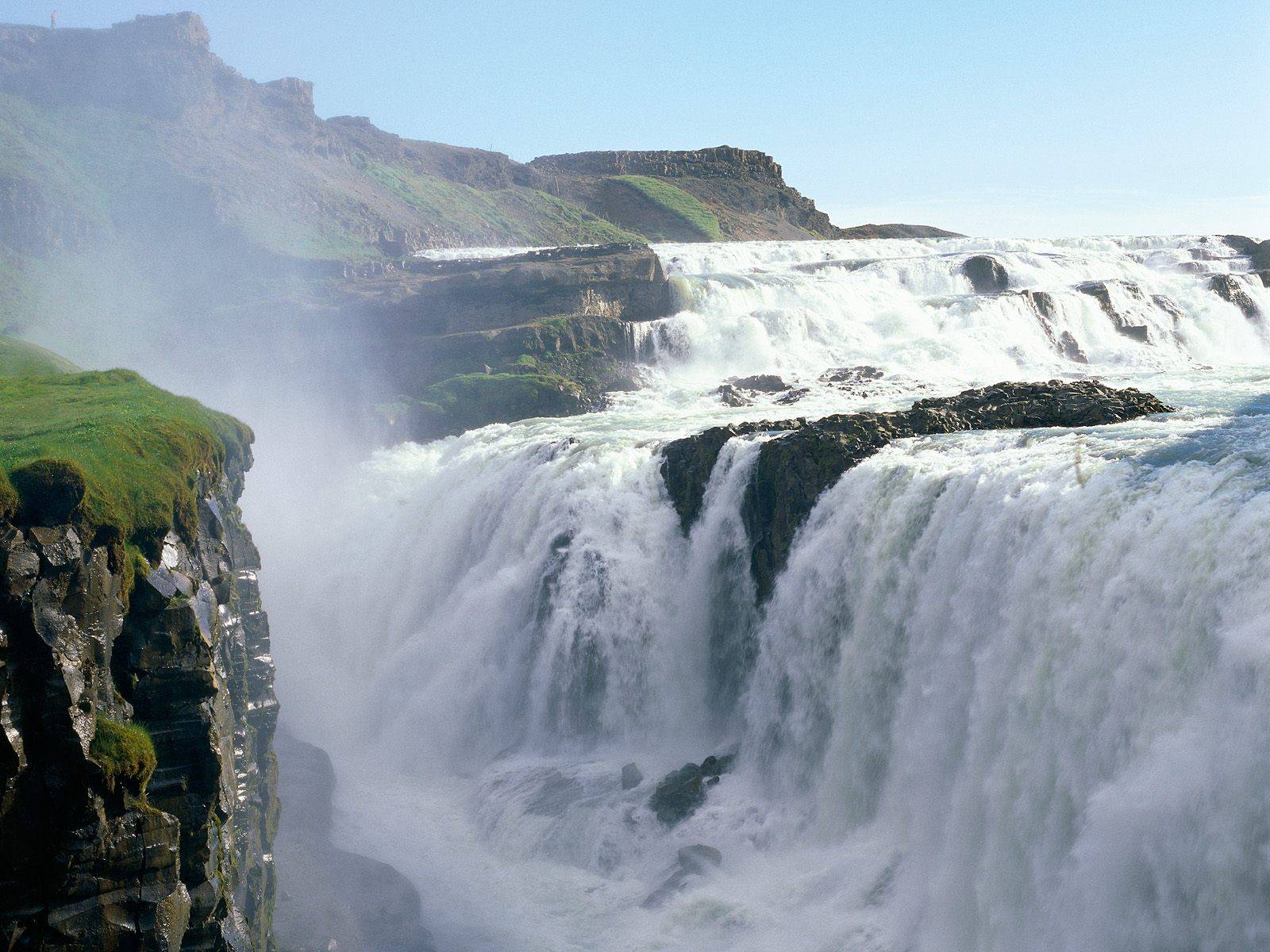
Plate Tectonic Tour: Post #7: Iceland Photos
My shack in Iceland that professor Sasha Ivan Merabishvili rented me! He works in Iceland too?!
Plate Tectonic Tour: Post #7: Iceland Photos

Hope this photo helps explain the divergent boundaries of Iceland... notice how the north american and Eurasian plates are pulling apart.
Plate Tectonic Tour: Post #7: Iceland Photos
Hope this photo helps explain the divergent boundaries of Iceland... notice how the north american and Eurasian plates are pulling apart.
Plate Tectonic Tour: Post #7: Iceland
Well guys… this is it… no, not for me, for plate tectonics… well actually plate tectonics for me… anyways… I left the Himalayas because I decided that my trip needed to come to an end since I learned so much about convergent divergent and transform plate boundaries and I missed home (well I honestly mainly left because I didn’t want the Yeti to capture me and therefore proceed to consume me). But before I go, I have one more post for you… Iceland. Yeaaaaap I lied, Iceland is my last stop. So we’ll talk about plate tectonics and stuff I did there. My last post is kind of boring because I’m so sad that my trip is over =[. Anyways, let’s get to it.
| | Iceland offers scientists a natural laboratory for studying - on land - the processes that occur along submerged parts of a divergent boundary. Iceland is splitting along the Mid-Atlantic Ridge - a divergent boundary between the North American and Eurasian Plates. As North America moves westward and Eurasia eastward, new crust is created on both sides of the diverging boundary. While the creation of new crust adds mass to Iceland on both sides of the boundary, it also creates a rift along the boundary. Iceland will inevitably break apart into two separate land masses at some point in the future; as the Atlantic waters eventually rush in to fill the widening and deepening space between. |
I typically learned this from… MYSELF. I went to an exhibit to learn about Iceland… just for yo info (ha ha like the “yo”? I thought so… I feel so cool…) Iceland is in the divergent plate boundaries. So enough about since I’m through with this geology stuff… I learned some… interesting things… facts, actually… sooo maybe this will wake you up a lil from reading this post?
Weird Iceland Facts:
Iceland consists of only 290,000 inhabitants/people.
60% of Iceland’s population lives in the capital, Reykjavík
Reykjavík means “Smoke-bay”’ that Tuesday, Wednesday, Thursday, and Friday are named after the Norse Gods: Tyr, Odin, Thor and Frey
Beer was banned in Iceland until 1989 Most Icelanders graduate from University at the age of 25-30
Iceland has twice as many sheep as people Boxing wasn’t allowed until 2002
We nearly have 24 hours of sunlight during summer During December we hardly even see the sun
We have 13 Santa Clauses.
We have myths about the Santa Clauses´ parents.
We learn Danish and English from the age of 11
“Sigurrós” (a very successful Icelandic music band) was woted the 10th best band in the world (by Newsweek)
We have made it to The Guinness Book of Records for drinking Coke.
Icelanders consume more Coca-Cola per capita than any other nation
We go to the movies more often per capita than any other nation
Travel + Leisure magazine, with nearly one million subscribers, cited Icelandair as one of the World’s Best International Airlines. Placing eighth with 73.62% of the vote, Icelandair received high marks for cabin comfort, food, in-flight service, customer service and value.
Iceland was the first country in the world to have a female president Our surnames consist of our fathers first name and then “son” or daughter”
We have the cleanest water in the world! We heat our houses with thermal water as well as our outdoor swimming pools
Some of the scenes for the movie “Lara Croft” (starring Angelina Jolie) were filmed on an Icelandic glacier
Also several James Bond movies
Most of Iceland graduate from High school at the age of 20.
Most nightclubs open at around 21:00 after midnight and close up around 8-9 in the morning.
Icelandic people can read scripts that are more than thousand years old, and that they are even taught in High school as Icelandic literature.
The most common names in Iceland are “Jón” like John, “Anna” like Anne.
We believe in elves and dwarves (in a sort of myth-way)
It’s a beautiful island with breathtaking enchanting nature!
Well guys, it's been a blast... but there is a season to life, and this "season" of this "blog" is ending... =[ Hope you learned stuff about plate tectonics, and convergent/divergent/transform plate boundaries... I'm heading back to Seattle, WA. Xbox 360 is waiting at home... Max out! BLAMMM
Plate Tectonic Tour: Post #6: Himalayas Photos

Yeeaaaaaaaaaaah that is high... higher then... a lot of things...? I don't know, just enjoy
Plate Tectonic Tour: Post #6: Himalayas Photos

From view of helicopter tour... I should really consider buying one... well then I'd be bankrupt... anyways, you guys should do one of these things someday, it's worth it. =]
Plate Tectonic Tour: Post #6: Himalayas Facts
"The Himalaya Range or Himalaya Mountains literally means "abode of snow", usually called the Himalayas or Himalaya for short, is a mountain range in Asia, separating the Indian subcontinent from the Tibetan Plateau. By extension, it is also the name of a massive mountain system that includes the Karakoram, the Hindu Kush, and other, lesser, ranges that extend out from the Pamir Knot.
Together, the Himalayan mountain system is the planet's highest, and home to the world's highest peaks, the Eight-thousanders, which include Mount Everest and K2. To comprehend the enormous scale of this mountain range, consider that Aconcagua, in the Andes, at 6,962 metres (22,841 ft) is the highest peak outside Asia, whereas the Himalayan system includes over 100 mountains exceeding 7,200 m (23,622 ft).
Some of the world's major rivers, the Ganges, Indus, Brahmaputra, Yangtze, Mekong, Salween, Red River, Xunjiang, Chao Phraya, Irrawaddy River, Amu Darya, Syr Darya, Tarim River and Yellow River, rise in the Himalayas, and their combined drainage basin is home to some 3 billion people (almost half of Earth's population) in Afghanistan, Bangladesh, Bhutan, People's Republic of China0, India, Nepal, Burma, Cambodia, Tajikistan,Uzbekistan, Turkmenistan, Kazakhstan, Kyrgyzstan,Thailand, Laos, Vietnam, Malaysia and Pakistan.
The Himalayas have profoundly shaped the cultures of South Asia; many Himalayan peaks are sacred in Hinduism, Buddhism and Sikhism. The main Himalaya range runs west to east, from the Indus river valley to the Brahmaputra river valley, forming an arc 2,400 km (1,491 mi) long, which varies in width from 400 km (249 mi) in the western Kashmir-Xinjiang region to 150 km (93 mi) in the eastern Tibet-Arunachal Pradesh region. The range consists of three coextensive sub-ranges, with the northernmost, and highest, known as the Great or Inner Himalayas." - Mrs. Bayaarma Anil (my militarian soldier tough guide!)
Plate Tectonic Tour: Post #6: Himalayas
Yo what is up!!! Alright so I just left Africa, and said goodbye to my friend Dawit... I will never ever forget that sunset... unless I suddenly forget... ok I'm not even making sense anymore. I flew all the way to the Himalayas to show ya'll something special. Himalayan mountain range, aka home of the yeti. Ha ha I'm risking my life for you guys so you better appreciate it... I heard that when one of those giant monkeys get a hold of you, there's no letting go... So let's see. Ok. Convergent plate boundaries.
First of all, mountain ranges are convergent plate boundaries. Here crust is destroyed and recycled back into the interior of the Earth as one plate dives under another. These are known as Subduction Zones - mountains and volcanoes are often found where plates converge. There are 3 types of convergent boundaries: Oceanic-Continental Convergence; Oceanic-Oceanic Convergence; and Continental-Continental Convergence. While new ocean crust is constantly being created at mid-ocean ridges, old crust must either be destroyed or reduced at the same rate (or else the planet would be continually expanding and increasing in volume). The plates, therefore, emerging along mid-ocean ridges, sliding over the athenosphere, and grinding past other plates along transform faults, are almost all headed on a collision course. When two continents carried on converging plates ram into each other, they crumple and fold under the enormous pressure, creating great mountain ranges. The highest mountain range in the world, the snow-capped Himalayas, is an example of a continent-to-continent collision. This immense mountain range began to form when two large landmasses, India and Eurasia, driven by tectonic plate movement, collided. Because both landmasses have about the same rock density, one plate could not be subducted under the other. The pressure of the colliding plates could only be relieved by thrusting skyward. The folding, bending, and twisting of the the collision zone formed the jagged Himalayan peaks. This string of towering peaks is still being thrust up as India, embedded in the Indo-Australian Plate, continues to crunch relentlessly into Tibet, on the southern edge of the Eurasian Plate.
Ok let me tell you some facts about this mountain range that Mrs.Bayarmaa Anil who works at a research facility in the Tibetan military. Awesome... I'm sooo jealous... I would like to shoot a PSG1 or a g11 assault rifle in real life... instead of pwning nOObs on call of duty black ops... anyways. Welllllll I'll say facts in the next post.
Sunday, April 10, 2011
Plate Tectonic Tour: Post #5: East Africa Rift
At the top of the East African Rift (valley)... I'm speechless.. here's the sunset I was talking about...

Plate Tectonic Tour: Post #5: East Africa Rift
Hey! So unfortunately, I had to depart from my friends professor Sasha and Chef (a scientist in disguise... but dang is the sushi good... good sake too... ok stop dreaming...) Takashima... they decided they'd work together to make a huge profit and become rich. A professor who rents places combined with a sushi-making scientist? Ohhhhhh heck yeah... I'll watch out for those guys in the next few years and if they get rich, I'll ask for some money and say "Do you remember me?"
Anyways, the next part of this tour is Africa. Yuppp where the lions roar and the zebras hop... or are those kangaroos? No, their giraffes... well actually giraffes are really tall. Did you know the giraffe has the biggest set of teeth out of any land animal? Yeah bet you didn't know that. Anyways, let's talk. I just got here at the airport, and let's just say it's hot. Burning hot. I feel like I'm burning up (Jonas bros). There are birds that have colors that I can't even explain. I can't even say rainbow. Buttt I'm not here for the wildlife (which is really stupid) I'm here for for plate tectonics. Now, this specific site is a divergent plate. At divergent boundaries new crust is created as two or more plates pull away from each other. Oceans are born and grow wider where plates diverge or pull apart. As seen below, when a diverging boundary occurs on land a 'rift', or separation will arise and over time that mass of land will break apart into distinct land masses and the surrounding water will fill the space between them. And that's exactly why I'm here... for the East African Rift! A rift or chasm is a place where the Earth’s crust and lithosphere are being pulled apart and is an example of divergent plate boundaries. So my guide Dawit is showing me around, and he said that Rifts turn out into valleys... and he was right. Check out this photo I took of the east African rift... this is just one side, the other is the exact same.
Yeah... if you want an awesome sunset, I recommend you come here... I was so close to the sun that I could see it going down by the hour and I think I even saw all the little craters in the sun... eh, no, actually I was going blind. My eyes just went from minus 3.0 to minus 5.0... Crap. So that's enough about science, I don't even like it that much. Or geology. I don't even know what I'm talking about. Here's what Dawit told me that might intrigue you to visit here. I feel like Mr. Takashima now... it's like working at a hotel when I tell people to come somewhere. Anyways, this is what I learned. The Eastern Rift Valley runs through Kenya from Lake Turkana in the north and beyond Lake Magadi in the South. It is the home to breathtakingly unique geographical features, including geysers, extinct volcanoes, gorges, escarpments, the Aberdare Range and numerous lakes. Some of the oldest human fossils have been found here. Anyways, I'll leave you with some photos and I'll talk to you soon... Max out.
Plate Tectonic Tour: Post #4: Japan Photos

Takashima showed me this... hope this helps... I know, your welcome...
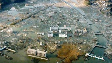
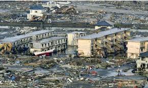

Plate Tectonic Tour: Post #4: Japan Photos

These are all helicopter photos of destruction in Japan (earthquake and tsunami) until further noticed...

Plate Tectonic Tour: Post #4: Japan
By the way, Tsunamis are giant waves caused by earthquakes or volcanic eruptions under the sea. Out in the depths of the ocean, tsunami waves do not dramatically increase in height. But as the waves travel inland, they build up to higher and higher heights as the depth of the ocean decreases. The speed of tsunami waves depends on ocean depth rather than the distance from the source of the wave. Tsunami waves may travel as fast as jet planes over deep waters, only slowing down when reaching shallow waters. While tsunamis are often referred to as tidal waves, this name is discouraged by oceanographers because tides have little to do with these giant waves.
Plate Tectonic Tour: Post #4: Japan
Yo yo yo so now that I'm all refreshed and my blog isn't acting like crap, I can tell you that I just landed on the eastern coast of Japan... they just renovated a brand new hotel since everything was... you know. Well, blue skies, blue ocean, fresh ocean breeze... everything's great... just kidding... not really... there's just barren landscape everywhere, burnt down and wrecked buildings... concrete walls and cracked fluorescent lights scattered across the road. Well, at least this little area is nice... artificial grass and such... it's a nice hotel... anyways, let's talk. Since I've made a dedication about talking about plate tectonics, I'll just have to talk about that instead of the great sushi I just had... did you know Japan's main source of food and occupation is fish? Yeah, big wowzer right there huh... well maybe the food part was obvious. Anyways, let's see. Right, Tsunami and earthquakes. Letsss talk earthquake first, since Tsunamis derive from Earthquakes. I'm talking to the hotel manager, Hataki Takashima who is an expert at this stuff, so you can all know that the following info is correct. This is what I learned...
An earthquake is caused by a sudden slip on a fault. The tectonic plates are always slowly moving, but they get stuck at their edges due to friction. When the stress on the edge overcomes the friction, there is an earthquake that releases energy in waves that travel through the earth's crust and cause the shaking that we feel.
You know how the Japanese video game company called "Atari" basically started this legend about "Godzilla"? And how that giant dino-bully would just come around and incinerate buildings and wreck havoc with it's 50000000000000000000 degree fiery dragon-breath? And how people actually believe it because they could feel it's giant unearthly feet? Yeaaaaah peeps I think that was an "earthquake" not a giant fictional gaming cartoon dragon guy that's from another dimension... I hope that scientists don't find a way to open a portal to another dimension... seriously bro, not a good idea. Anyways, let me tell you about how Earthquakes are related to Tsunamis.
Again, I'm too lazy to write things in my own words, so I decided to quote Takashima.. here's what he said... by the way, his hamachi and sake sushi is the absolute best... anyways, here you go:
"So Tsunamis are giant waves caused by earthquakes or volcanic eruptions under the sea. Out in the depths of the ocean, tsunami waves do not dramatically increase in height. But as the waves travel inland, they build up to higher and higher heights as the depth of the ocean decreases. The speed of tsunami waves depends on ocean depth rather than the distance from the source of the wave. Tsunami waves may travel as fast as jet planes over deep waters, only slowing down when reaching shallow waters. While tsunamis are often referred to as tidal waves, this name is discouraged by oceanographers because tides have little to do with these giant waves.
The largest tsunami on record rushed past Ishigaki Island, Japan, in 1971. It was an incredible 84.7 meters (278 feet) high. While it caused little damage, the giant wall of water relocated a 750-ton block of coral 2.4 kilometers (1.5 miles) inland."
So I hope that Takashima there explained stuff pretty well... so that about does it for the post... I'm back to sushi and some hot sake... still a nice city, just needs to be rebuilt. Imma show you the photos I took... got another helicopter tour. Helicopters for the win. Peace and God bless ya Japan! Get well soooooon you already survived the storm anyways you guys the toughest... =D
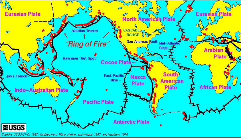
Plate Tectonic: Post #3
Ok so my blog is kind of freaking out but anyways, Sash said the ring of fire is: "The Pacific Ring of Fire (or sometimes just the Ring of Fire) is an area where large numbers of earthquakes and volcanic eruptions occur in the basin of the Pacific Ocean. In a 40,000 km (25,000 mi) horseshoe shape, it is associated with a nearly continuous series of oceanic trenches, volcanic arcs, and volcanic belts and/or plate movements. The Ring of Fire has 452 volcanoes and is home to over 75% of the world's active and dormant volcanoes. It is sometimes called the circum-Pacific belt or the circum-Pacific seismic belt."
Plate Tectonic Tour: Post #2 (Professor Sasha's diagram)

Hope this helps you understand how volcanoes work and how their formed... yeah, it's really related to plate tectonics.
Plate Tectonic Tour: Post #3: Ring of Fire
Since I talked about volcanoes in the past, and I'm so bored that even that photo of Kamchatka lake couldn't arouse me. So let's talk...
Ok so the Ring of Fire is... well holdup, let me ask Professor Sasha who is coming with me to explore and photograph our next destination. But let's talk about this right now.
Ok, so he just explained it to me... you know, I don't want to say things out of my mouth because I'm so tired, so I'm just going to quote him.
Sasha says:
"The Pacific Ring of Fire (or sometimes just the Ring of Fire) is an area where large numbers of earthquakes and volcanic eruptions occur in the basin of the Pacific Ocean. In a 40,000 km (25,000 mi) horseshoe shape, it is associated with a nearly continuous series of oceanic trenches, volcanic arcs, and volcanic belts and/or plate movements. The Ring of Fire has 452 volcanoes and is home to over 75% of the world's active and dormant volcanoes. It is sometimes called the circum-Pacific belt or the circum-Pacific seismic belt.
After about 10 million years, the final stage of subduction begins. At depths of as much as 450 miles, the plate becomes so hot that it softens and stops generating earthquakes. But the descent and melting continue until, at some unknown depth, the plate blends with the surrounding mantle material. Eventually this material will emerge along Mid-Ocean Ridges as new sea-floor crust or escape as volcanic lava as the process of subduction comes full circle and our tectonic planet continues to evolve."
Alrighttty so I guess that explains it? Sasha does an excellent job so I'm just going to assume he is right... I'm almost at... Japan.. eh, that's right! So I'll see you there... I honestly don't even know what I'm talking about anymore I feel like there's sand in my eyes but it's probably just eye wax or whatever the heck it's called so peaceee
Plate Tectonic Tour: Post #2 (Kamchatka lake on top of volcano Avanchinsky)
Uhhhhh yeah... that... that just happened... and I don't know what to say about this so I'll talk to you later.
Plate Tectonic Tour: Post #2 (Volcano Explanation)
That was awesome... my cabin at the bottom of the Avachinsky volcano was actually designed to prevent avalanches... no windows, but the outer shell was designed with iron rods... huh. Smart people. Oh, and I don't want to forget about that boat tour on the lake. I sweaaar I saw the biggest fish... actually I don't even think it was a fish... anyways, you saw the two photos I took... my crappy flip camera ran out of battery... I should really consider taking out the Canon 7d... the big boy... to bad it's so expensive I'm scared to use it... ok ok getting off topic again. I feel like I'm abusing my job as a photojournalist but having too much fun... Sooo the main reason I wanted to post this is to explain to you the details of a volcano, and the volcanoes I visited as well. Koryaksky lies on the Pacific Ring of Fire, at a point where the Pacific Plate is sliding underneath the Eurasian Plate at about 80 mm/year. A wedge of mantle material lies between the subducting Pacific Plate and the overlying Eurasian Plate is the source of dynamic volcanism over the whole Kamchatka Peninsula. The volcano has probably been active for tens of thousands of years. Geological records indicate that there have been three major eruptions in the last 10,000 years, at 5500 BC, 1950 BC and 1550 BC. These three eruptions seem to have been mainly effusive, generating extensive lava flows. So basically if you divide that by 3, theres about 1 volcanic eruption every 3,300 years? I have no clue, my math is bad... plus, I'll be dead by then so it doesn't even matter... unless I freeze myself, and then defrost myself approximately 3,300 years later... I have no idea, but that probably won't happen plus the rate of volcanic eruptions will change for sure. Nowww I'll tell you how volcanoes are formed. You know what tectonic plates are, right? Since it is related to volcanoes, I'll just say it... my tour guide (who really turned out to be a accomplished and famed scientist that retired) that rented me my awesome (and avalanche-proof) cabin at the bottom of stratovolcano Avachinsky told me this:
"Most volcanoes are formed by the movement oftectonic plates on the surface of the earth. These plates are basically huge pieces of rock that ‘float’ on the mantle (a layer of the earth that is sort-of liquid rock).When a tectonic plate sinks, it sinks down into the mantle and becomes very hot. So hot, in fact, that the rock melts. This molten rock will gradually make its way up to the surface of the earth through a series of cracks. When it reaches the surface of the earth, we refer to it as lava. As layer upon layer of lava builds up, a volcano is formed." Proffesor Sasha Ivan Merabishvili
Anywaysss... I think that did it for now. IT WAS SO AWESOME! And by the way, the captain of my boat tour offered me to go on a helicopter tour on top of volcano Avachinsky to see something very interesting... I took a picture. Let's just say I was more excited the seeing a skate-boarding flying pig with the face of Charlie Sheen. Check it out on my next post.
Plate Tectonic Tour: Post #2 (Avachinsky-Koryaksky volcanoes)

Here is the view of the Koryaksky volcano from my boats point of view.
Saturday, April 9, 2011
Plate Tectonic Tour: Post #2 (Avachinsky-Koryaksky volcanoes)

My rented cabin at the base of the Avachinsky stratovolcano!
Wednesday, April 6, 2011
Plate Tectonic Tour: Post #2
Hellllllo Lakeside Army! For this second part of this post, I wanted to talk about my second stop... this is freshhh since I just got here by plane... Russia! Ohhh yeah that is right, I'm here to visit volcanoes. Specifically, the Avachinsky and Koryaksky volcanoes., located in Kamchatka.These volcanoes are side by side, kind of like siblings. They are also stratovolcanoes... I'll explain that later. But for now, here are some pictures of these fantastic volcanoes...

Plate Tectonic Tour: Post #1 (Mariana wildlife)

This is right below the surface of Mariana trench... pretty colors!
Tuesday, April 5, 2011
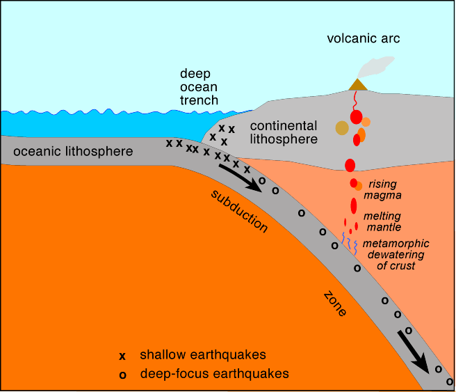
Plate Tectonic Tour: Post #1
Hello Army! Today, I wanted to talk about something very special (it is also my first installment of my Plate Tectonic Tour). I will talk about what it is, where it was, and how it relates to our earth's lithosphere and plates. So... let’s get started?
For those of you who didn’t know, I've decided to take on my role of a photo journalist and take pictures that go along with the subject. So today’s subject is… Trenches! Yup, the deep sea oceanic trenches, those giant cracks in the ground. Surprisingly, I learned from accomplished earth scientist Antonio Hopson that trenches define one of the most important natural boundaries on the Earth’s solid surface: the one between two lithospheric plates. There are three types of lithospheric plate boundaries: divergent (where lithosphere and oceanic crust is created at mid-ocean ridges), convergent (where one lithospheric plate sinks beneath another and returns to the mantle), and transform (where two lithospheric plates slide past each other). In a better overview, the oceanic trenches are hemispheric-scale long but narrow topographic depressions of the sea floor. They are also the deepest parts of the ocean floor. So I flew myself all the way to the deepest trench in the world… Mariana trench! The Mariana trench is located near the Mariana Islands in the pacific islands… here is a description straight from a jolly scientist I met there: “The Mariana Trench is the deepest part of the world's oceans, and the lowest elevation of the surface of the Earth's crust. It is currently estimated to be up to 10,971 m (35,994 ft) deep. It is located in the western Pacific Ocean, to the east of the Mariana Islands. The trench is about 2,550 kilometres (1,580 mi) long but has a mean width of only 69 kilometres (43 mi). It reaches a maximum-known depth of about 10.91 kilometres (6.78 mi) at the challenger deep, a small slot-shaped valley in its floor, at its southern end; Although, some unrepeated measurements place the deepest portion at 11.03 kilometres (6.85 mi). If Mount Everett, the highest mountain on Earth at 8,848 metres (29,029 ft), were set in the deepest part of the Mariana Trench, there would be 2,076 metres (6,811 ft) of water left above it.”
Because the altitude was so low, I wasn’t able to take any photos… So I apologize. I’ll leave you with a diagram that I saw on the submarine about how trenches are related to plate tectonics and the lithosphere, and I’ll see you next time!
Plate Tectonic Tour: Introduction
For this part of this site, I wanted to try something new...
Hello Lakeside Army! My name is Max Ma (not Max Murin) and I'm a photo journalist interested in plate tectonics, and how our Earth's lithosphere works. At this part of the year, life is boring. Well to be frank, it sucks. So I've decided to take a tour around the world and inspect locations that are "lithophere"ically interesting. During this tour, YOU are the audience. I'm deciding to record every single place I go to and explain how it is related to Earth's lithosphere, along with including some pictures that I was able to take (well duh I am a PHOTO JOURNALIST!). I'm going to show ya'll around the world and how to survive... ha ha just kidding but I will be traveling along. So, the first post of my tour is about to be posted so here we go!
Subscribe to:
Posts (Atom)